|
FEMA Grounds Private Drones That Were Helping To Map Boulder Floods, Threatens To Arrest OperatorsTechdirtSep. 17, 2013 |
Popular 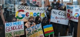
'Woke' Google Fires 28 Employees Who Protested Gaza Genocide

Report: Blinken Sitting On Staff Recommendations to Sanction Israeli Military Units Linked to Killings or Rapes

America Last: House Bill Provides $26B for Israel, $61B for Ukraine and Zero to Secure U.S. Border
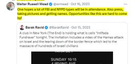
Bari Weiss' Free Speech Martyr Uri Berliner Wants FBI and Police to Spy on Pro-Palestine Activists

John Hagee Cheers Israel-Iran Battle as 'Gog and Magog War,' Will Lobby Congress Not to Deescalate
 As you may have heard, Boulder, Colorado has been hit by massive flooding over the past week, and it's been something of a mess. A local company, Falcon UAV, makers of special drones which are built for the government, approved by the FAA, and specialize in using GPS and cameras to generate highly accurate maps, started helping to map the damage with those drones. Read More |